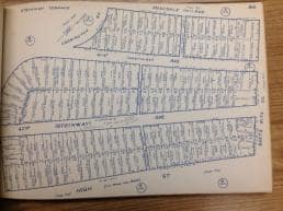
Researchers can use several handy tools at the Oakland History Center to discover the history of their homes and businesses.
The houses many of us live in have long and fascinating histories. Some are architecturally distinguished, some have been moved from other locations, some are the former homes of important people. For those of you interested in finding out more about your house, a trip to the Oakland History Center (OHC) may answer your questions.

A first stop should be to OHC's Map Room where patrons can find their houses in tax assessment block books (1877-1925) and Sanborn Fire Insurance maps (1882-1951). There you can find out names of previous owners, property values, physical information about the house, and prior street names. Another important resource in the Map Room is the Oakland annexation map. The city grew by five annexations; knowing when your neighborhood became part of Oakland helps facilitate your search. Researchers can then consult Oakland city directories (in OHC's Main Room) to find out more about the owners. Some, for example, were contractors, possibly the builders of their properties.
Further investigation can lead you to the History Center's extensive photograph collection. It's a long-shot but sometimes you can find photos of your house in old neighborhood photographs. Another invaluable resource is "Quentin's Guide to the Streets of Northern Alameda County." This directory shows street name changes, an important tool to have when searching for old houses.
Another little-used but important resource is the Donough real estate listings, profiled here by Oakland History Room volunteer Mike Griffith:
A. Ormsby Donogh sold real estate in the East Bay for over thirty years, from the 1940s into the 1970s. Although located on Shattuck Avenue in downtown Berkeley, he listed properties in all areas of Oakland as well.
Donogh’s Oakland records at the Oakland History Center consist of about 5,000 file cards, each documenting a property for sale. Although they range from 1941 to 1977, the bulk of the collection is mainly from the 1960s. The cards are arranged alphabetically by street names. Numbered streets and avenues are interfiled as if their names were spelled out (e.g., 35th Avenue is filed under “T” and 98th Avenue under “N”).
The listings can be a rich source of information about a property. All the cards include at least an address, the price asked for the property, and a listing date. Many, however, have an envelope attached to the card with much more information, including owner’s name, age of building, and a brief verbal description. In the case of rental properties, the rental income may be listed. Best of all, in quite a few cases, the envelope contains a photograph of the property or a photocopy of a picture. All the properties appear to be residential, single family or multi-unit buildings. When you visit the Oakland History Center just ask a staff person to direct you to this collection. It offers an excellent way to begin a house history search.


Add a comment to: Researching Your House’s History at OPL